
Victor Vescovo’s marine technology company, Caladan Oceanic, has recently teamed up with TCarta and the Greenwater Foundation to provide Kenya with detailed maps of its coastal seafloor.
Oceans cover more than 70% of our planet, yet only about 26% of the seafloor has been mapped in detail. Without accurate maps, it’s hard to manage marine resources, protect coastal communities, or understand how the ocean affects global climate and ecosystems.
Caladan Oceanic’s project with TCarta and the Greenwater Foundation supports the global Seabed 2030 Project, which aims to map the entire ocean floor by the end of the decade.
Here’s what this means for Kenya and the world.
What’s Happening?
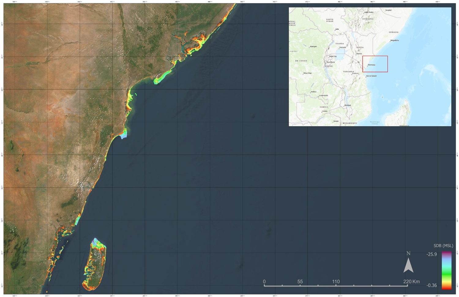
Using advanced satellite technology, the project has created high-resolution maps of Kenya’s coastal waters, covering over 2,500 square kilometers.
These maps, with resolutions as fine as 10 meters, will help Kenya better understand its coastal areas, manage fisheries, identify potential hazards like reefs and sandbars, and support marine research. The data has already been shared with the Kenyan government and will be freely available to the public through the Seabed 2030 initiative.
How Does It Work?
The project uses Satellite-Derived Bathymetry (SDB) which, Instead of relying on ships or planes to map the seafloor, uses satellite imagery to “see” through the water and create detailed maps. This method is faster, cheaper, and more environmentally friendly than traditional approaches. It’s also ideal for areas like Kenya, where tropical storms frequently reshape the seafloor, making repeated mapping necessary.
What Are the Benefits?
- •Safety: The maps can help identify underwater hazards, making coastal navigation safer for ships and boats.
- •Resource Management: Better maps mean better management of fisheries and other marine resources, which are vital for Kenya’s economy and food security.
- •Environmental Protection: By locating reefs and other critical habitats, the maps can help protect biodiversity and support conservation efforts.
- •Global Impact: The data contributes to the Seabed 2030 Project, which aims to create a complete map of the ocean floor by 2030. This will benefit scientists, governments, and communities worldwide.
What Do the Experts Say?
Victor Vescovo of Caladan Oceanic highlighted the importance of using existing technology to create maps for areas that were previously unmapped. “This is just the beginning of a significant effort to generate more coastal maps and share them with the world for free,” he said.
Commander G. Mark Miller, co-founder of the Greenwater Foundation, emphasized the challenges of ocean exploration. “The ocean is hard to map—it’s hard on equipment, hard on people, and expensive. But by using new technology, we can finally start to understand and protect it.”
Kyle Goodrich, CEO of TCarta, pointed out that SDB is uniquely suited for rapid and repeated mapping of coastal areas, making it a game-changer for regions like Kenya.
Jamie McMichael-Phillips, Director of the Seabed 2030 Project, praised the collaboration, saying it brings the world closer to the goal of a fully mapped ocean floor by 2030.
What’s Next?
This project is a model for how technology and collaboration can address global challenges. By reducing the cost of mapping and making data freely available, initiatives like this can help protect our oceans, support coastal communities, and advance scientific understanding. For Kenya, the new maps are a valuable tool for sustainable development and environmental conservation. For the world, they’re another step toward understanding the vast, mysterious depths of our planet’s oceans.